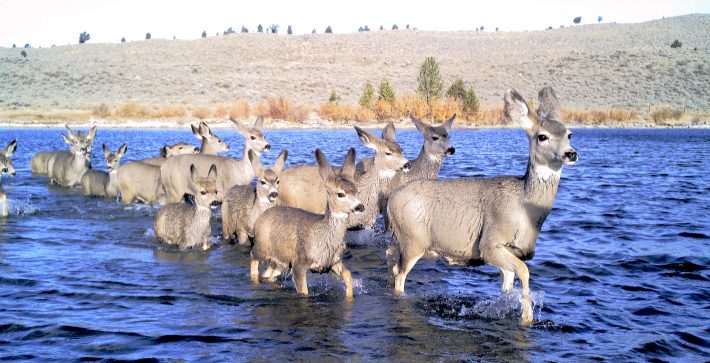
Predicting migration pathways of Mule Deer without GPS collars
University of Wyoming press release.
Scientists have developed promising models to predict where mule deer are likely to migrate, without the need for collaring new animals.
How do researchers understand where big-game animals migrate across vast landscapes each spring and fall? That is the question asked by biologists from the University of Wyoming and Idaho Department of Fish and Game in a study published in the British Ecological Society journal Methods in Ecology and Evolution.
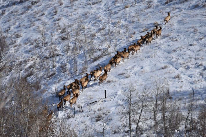
Recent advances in technology have allowed biologists and wildlife managers to track ungulates, like elk and mule deer, with GPS collars that reveal the animals’ migratory pathways. But collars are expensive and logistically challenging to deploy, making it difficult to build a comprehensive inventory of the corridors the herds require.
Now, a research team has found a promising way to predict where mule deer are likely to migrate, without the need for collaring new animals.
“We were surprised at how well we were able to predict most deer movements, which suggests that instead of moving randomly, migrating mule deer appear to follow rules that do a good job of balancing the costs of moving with the benefits of forage access,” says Tristan Nuñez, who led the work as a postdoctoral researcher at the U.S. Geological Survey’s Wyoming Cooperative Fish and Wildlife Research Unit at the University of Wyoming.
The ability to predict fine-scale migration routes will save an immense amount of time and money
Nuñez tackled a question that has long plagued biologists: Can we predict migration corridors in areas without any GPS-collared animals, by using the information they have already learned about the habitats that tracked animals choose to migrate through?
Previous research relied on GPS data to map migration corridors, which has proven a powerful means for science-based management and conservation. But Nuñez and his co-authors held out hope that they could identify the migratory paths based on environmental information or habitat quality alone.
To answer this question, the research team first created models estimating a mule deer herd’s movement based on terrain, snowmelt, the intensity of human development, and new grass growth. Then, they compared those predicted corridors to the actual migration routes of 130 mule deer from three GPS-collared herds in Idaho and Wyoming.
The team’s models acted like a wayfinding app on smartphones that identifies the best route to navigate between two points. For mule deer, however, the predicted corridor that best matched the actual spring movements wasn’t a straight line, or shortest distance, between their summer and winter range. Instead, the deer generally preferred routes with hilly terrain, shrubby vegetation, and less human development.
“The ability to predict fine-scale migration routes will save an immense amount of time and money, and ultimately be more useful for managing wildlife in Idaho,” says study co-author Mark Hurley at Idaho Department of Fish and Game.
Traditionally, wildlife managers relied on GPS data from collared animals to define migration routes, which are critical for healthy ungulate populations. However, detailed knowledge of the seasonal migrations depends on years of time-intensive and expensive data collection. “Even after collaring thousands of animals, we have likely only fully described a fraction of the migration routes used throughout the state,” Hurley says.
Over the past few years, biologists and wildlife managers have used datasets from GPS collaring to map the migrations of more than one hundred ungulate herds across the western United States.
The work, along with the current study, has been made possible through a partnership known as the Corridor Mapping Team. The team was established in 2018 by the U.S. Geological Survey in response to Secretarial Order 3362 to promote mapping and conservation of ungulate migration corridors.
State wildlife agencies, tribes, and federal researchers uses GPS movement data to map migrations and support regional big-game management and conservation. The predictive migration models are an alternative to costly and labour-intensive animal tracking, benefiting the conservation of migrations that haven’t yet been mapped.
Even after collaring thousands of animals, we have likely only fully described a fraction of the migration routes
Ungulates like mule deer move throughout the western United States each spring and fall, in tune with environmental cues tied to food. But, as the human footprint in the West expands, migratory herds increasingly face obstacles such as new subdivisions, energy development, impermeable fences, and high-traffic roads on their long journeys.
The new computer algorithms used to predict the migratory routes will be freely available, allowing wildlife managers in areas where herds have never been collared to better understand where key migrations might occur. Mapped migrations can then guide where to make fences more deer-friendly, prevent subdivisions, or build overpasses to ease passage across busy highways to keep large landscapes open for ungulate migrations.
Working with members of the Corridor Mapping Team, Nuñez hopes to extend the work to other big-game species, herds, and landscapes across the western United States and beyond, to better understand how their movement preferences vary. Additionally, he says, the models can help shed light on how climate change will influence ungulate migrations in the future.
You can access the full research article for free here:
https://besjournals.onlinelibrary.wiley.com/doi/full/10.1111/2041-210X.13969
Like what we stand for?
Support our mission and help develop the next generation of ecologists by donating to the British Ecological Society.