Show me your leaves – Health check for urban trees
This week at the ‘Ecology Across Borders’ conference in Ghent, Belgium researchers from KU Leuven will present a fast, cost-efficient and objective method to map, evaluate and monitor the health of urban trees.
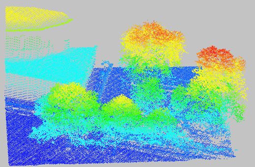
The researchers combined images from two specialised sensors mounted in airplanes to evaluate the density and colour of leaves on individual trees in the city of Brussels. First, they used LiDAR (Light Detection and Ranging) data to detect and delineate individual trees. LiDAR data consists of very accurate distance measurements between the airplane and objects on the ground, generating a detailed 3D representation of the city.
Secondly, they employed hyperspectral data to determine the density and health of the trees’ leaves. ‘Hyperspectral’ means that the wavelength pattern of light reflected from objects is measured in very high resolution. Each object reflects different parts of the light’s spectrum depending on its properties like colour, chemical components and structure. As trees suffering from a disease or environmental stress become less green and have less leaves (showing more of the surface below), this data allows to distinguish healthy from unhealthy trees.
This study focuses on the four most common tree species used in public green spaces and along roads in Brussels and in other Flemish cities, i.e. maple (Acer spp.), horse chestnut (Aesculus hippocastanum), sycamore (Platanus spp.) and lime (Tilia spp.). Information from airplane data was compared with traditional field inventories of ca. 25 trees for each species.
“This airborne mapping of tree health represents a huge extension to the currently implemented, labour-intensive field inventories and could thus greatly benefit urban green managers”, says Jeroen Degerickx, the lead author of this study. “Remote sensing technology definitely holds great potential for research on urban tree health. Unlike field inventories, the information extracted from remote sensing data is more objective, quantitative, covers a large and continuous area at once and can be easily repeated over time”, he adds.
Trees in urban areas suffer from all kinds of different stress factors which are not or much less present in natural environments. Soil and air pollution result in urban trees ingesting high quantities of heavy metals and other harmful substances. Trees along roads are often damaged by the excessive amounts of salt that are dispersed in winter to keep roads ice-free. Soils in urban environments are often very shallow (e.g. due to the presence of underlying structures) and trees are frequently planted in very confined spaces. Both of these factors are limiting space for roots to grow and hence increase the risk of water and nutrient stress. The risk of water stress in urban environments is additionally aggravated by the fact that cities are warmer compared to the surrounding rural areas, a phenomenon termed the urban heat island effect.
“Given the elevated occurrence of stress factors in urban environments, in combination with the clear implications of tree health on the functioning and stability of urban ecosystems and on the quality of life of its inhabitants, I would say that urban tree health in general is or should be an important issue to be considered in any city and any country across the globe”, Degerickx says.
There are plans to implement the new method in public monitoring schemes in the near future. “We are already in contact with the urban green management team of Brussels and the overarching organisation for public green spaces in Flanders (VVOG), which both clearly expressed their interest in our research, indicating that urban tree health is indeed a pressing issue”, states Degerickx.
This study is part of the international research project UrbanEARS, which explores the potential of remote sensing data to model water and heat dynamics in urban environments. As urban green areas are known to have major impacts on these dynamics, an important part of the project is dedicated to mapping and characterising these areas.
The ‘Ecology Across Borders’ conference is jointly organised by the British Ecological Society, Gesellschaft für Ökologie (the Ecological Society of Germany, Switzerland and Austria), and Dutch-Flemish Ecological Society (NecoV), in association with the European Ecological Federation, bringing together 1,500 ecologists from around 60 countries to discuss the latest advances in ecological research across the whole discipline.
Like what we stand for?
Support our mission and help develop the next generation of ecologists by donating to the British Ecological Society.